Floods have always been a fact of life for Manitobans. In colonial days, settlers would flee to high ground at places like Bird’s Hill. In the 1900s, however, Manitoba’s population boomed and its building infrastructure expanded. The Great Flood of 1950 saw over 10,500 homes flooded (1/10th of Winnipeg). The great potential damage future floods could do became a major concern.
New dikes and pumps were put in place, but when the Department of Resources and Development’s 1953 report recommended a huge river diversion channel be dug, Premier Douglas Campbell (1948-1958) hesitated at the cost. The succeeding Progressive Conservative government under Dufferin Roblin (1958-1967), however, leapt into construction of the Red River Floodway and other flood prevention projects. Critics nicknamed the floodway “Duff’s Ditch” and “decried [it] as ‘approximating the building of the pyramids of Egypt in terms of usefulness.'”
The floodway runs from just south of St. Norbert to the locks at Lockport (29 miles) and cost $62.7 million to construct. Manitoban companies moved more earth than it took to dig the Suez Canal, and 40% as much as the Panama canal. The St Lawrence Seaway took only two thirds the digging. Amazingly, they finished it without overruns in cost or time between 1962 and 1968.
The floodway proved its worth many times since 1950. Damage was minimized in floods of similar size in 1974 and 1979, and only 30 houses in Winnipeg flooded in the 1997 “Flood of the Century,” the largest since 1826. South of St. Norbert, 28,000 Manitobans were evacuated as a lake five and a half times the size of Winnipeg formed, and Grand Forks, ND was inundated. Winnipeg was saved, but only just. The waters almost went around the floodway gates!
The Floodway Expansion Project which concluded in 2010 doubled its capacity to accommodate the estimated size of a 1 in 700 year flood. It cost almost three times as much as the original project but has saved Manitoba billions of dollars in flood damage since its completion.
“Duff’s Ditch” was designated as a National Historic site in 2006. Its success is a tribute to the fruits of Canada’s heritage of enterprise and organization.
Red River Floodway (“Duff’s Ditch”)
The Red River Floodway geocache site is located near Lockport, Manitoba, Canada at N 50º 05.481´ latitude and W 96º 55.858´ longitude. If you find the geocache and scan the QR code inside of it, it brings you here to learn more. Watch all of our videos on our YouTube Channel. Other heritage content can be found on our Red River North Heritage Youtube channel.
Transcription:
“Roblin’s Folly!” cried the liberal opposition when they heard the proposed floodway would cost Manitoba 63 million dollars. Some said it wouldn’t even work. Others said another big flood was unlikely anyway.
After the great flood of 1950, studies commissioned by Douglas Lloyd Campbell’s government scrambled to find a way to protect Winnipeg from the Red River. They suggested making the river wider and deeper, building dams, or building a floodway. No solution would be easy.
Campbell brought forward a modest new three-point plan for fighting floods. In contrast to his cautious statements however, Winnipeg papers shouted for action.
The Free Press warned that “The city suffers a handicap in industrial development because of the so far undealt with danger of flooding.
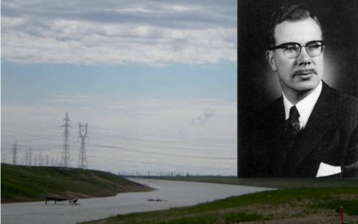
MLA Dufferin Roblin started raising his voice in the legislature. He insisted that Winnipeg needed the floodway. Roblin’s Progressive Conservatives won a minority government in 1958, and a majority in 1959.
Even with a majority, Roblin encountered difficulties. Once he won over his own party, there was still the issue of money.
While Agriculture and Conservation Minister George Hutton had a debate with the opposition in the assembly, Roblin met with Prime Minister John George Diefenbaker and managed to secure partial federal assistance for the project.
On October 6, 1962, three years into Roblin’s majority, the floodway broke ground. It took until 1968 to complete, moving more dirt than the original Suez Canal route had to in the process. By stretching out the project, his government built it without debt spending.
The floodway’s value was quickly recognized, and it was expanded after the 1997 “flood of the century” to protect Winnipeg from a 700-year flood as opposed to a 160-year flood.
Roblin’s long-term foresight saved billions of dollars in flood damage, and made Winnipeg safe for homes and industries.