The rural municipality of St. Clements comprises of all those portions of townships 13, 14 and 15 in range 5 east lying to the east of the Red River and outside the limits of the Parishes of St. Andrews, St. Clements and St. Peters; all that portion of township 16 in range 5 east lying to the south of Lake Winnipeg which lies to the east of the west channel of the said Red River flowing through sections 9, 16, 21, 28 and 29 in said township and range as the same are shown on a plan of special survey registered in the Winnipeg Land Titles Office as No. 3764, the south half and the northwest quarter of section 4, sections 5, 6, 7 and 8, the west half of section 9, the north half of the west half of legal subdivision l5 of said section 9, section 16 to 2t both inclusive and sections 28 to 33 both inclusive in township 13, in range 6 east; the most westerly 4 tiers of sections in township 14 in range 6 east; all that portion of township l5 in range 6 east which lies outside the limits of Brokenhead Indian Reserve No. 4; all that portion of township 16 in range 6 east lying to the south of Lake Winnipeg which lies outside the limits of Brokenhead Indian Reserve No. 4; all that portion of the north half of township 15, in range 7 east which lies Outside the limits of said Brokenhead Indian Reserve No. 4; the north half of township 15 in range 8 east; all that portion of township l6 in range 7 east which lies outside the limits of the said Brokenhead Indian Reserve No. 4; the most westerly 2 tiers of sections in township 16 in range 8 east; all that portion of township 17 in range 6 east, which lies to the east of Lake Winnipeg; fractional sections 12 and 13 in township 18, in range 6 east; sections 3 to l0 both inclusive, whole or fractional the south half of section 17, the northeast quarter of section 17 and all that portion of the northwest quarter of section 17 which lies to the west of the eastern limit of Lake Winnipeg according to a plan of said township approved and confirmed at Ottawa on June 28, 1912, fractional section l8 and all that portion of the fractional southeast quarter 0f section 32 which lies to the northwest of the southeastern limit of the lands taken for the right-of-way other Canadian Northern Railway and the production of said southeastern limit, as said right-of-way is shown on a plan filed in the Winnipeg Land Titles Office as No. 2509, all in township 18 in range 7 east; all those portions 0f the Parishes of St. Clements and St. Peters which lie on the east side of the Red River and all that portion of the Parish of St. Andrews lying on the east side of the said Red River which is not contained within the limits of the Birds Hill Provincial Park as the same is shown on a plan filed in the said Office as No. 9978.
AUTHORITY
S.M.43 Victoria 1880 Cap. I, Sec. XC, No. 24 shows the Municipality of St. Andrew’s shall comprise the electoral divisions of St. Andrew’s and St. Clements. (R.S.M. 1880-1881 shows these electoral divisions to be: XXIX Electoral Division No. 21 or St. Clements shall comprise that portion of the Parishes of St. Andrew’s south, St. Andrew’s north, St. Clements and St. Peter’s east of Red River together with townships 13 to 17 both inclusive, ranges 6, 7, 8, 9 and l0 east.
XXX Electoral Division No.22 or St. Andrew’s shall comprise those portions of the parishes of St. Andrew’s south, St. Andrew’s north, St. Clements and St. Peter’s west of Red River with east half of townships 13 to 17 both inclusive, range 3 east and townships 13 to l7 both inclusive, range 4 east.
Assented to and in force February 14, 1880.
S.M. 1881, Cap. 3, Sec. CLXXMO. 24 shows the municipality of St. Andrew’s shall comprise the electoral divisions of St. Andrews and St. Clements. (R.S.M. 1880-1881 – see description in Cap. 1 S.M. 1880)
Assented to May 25, 1881. In force after the election of Council under said Act.
S.M.46 and 47 pictorial 1883, Cap. I, Sec.20 (No.2) shows:
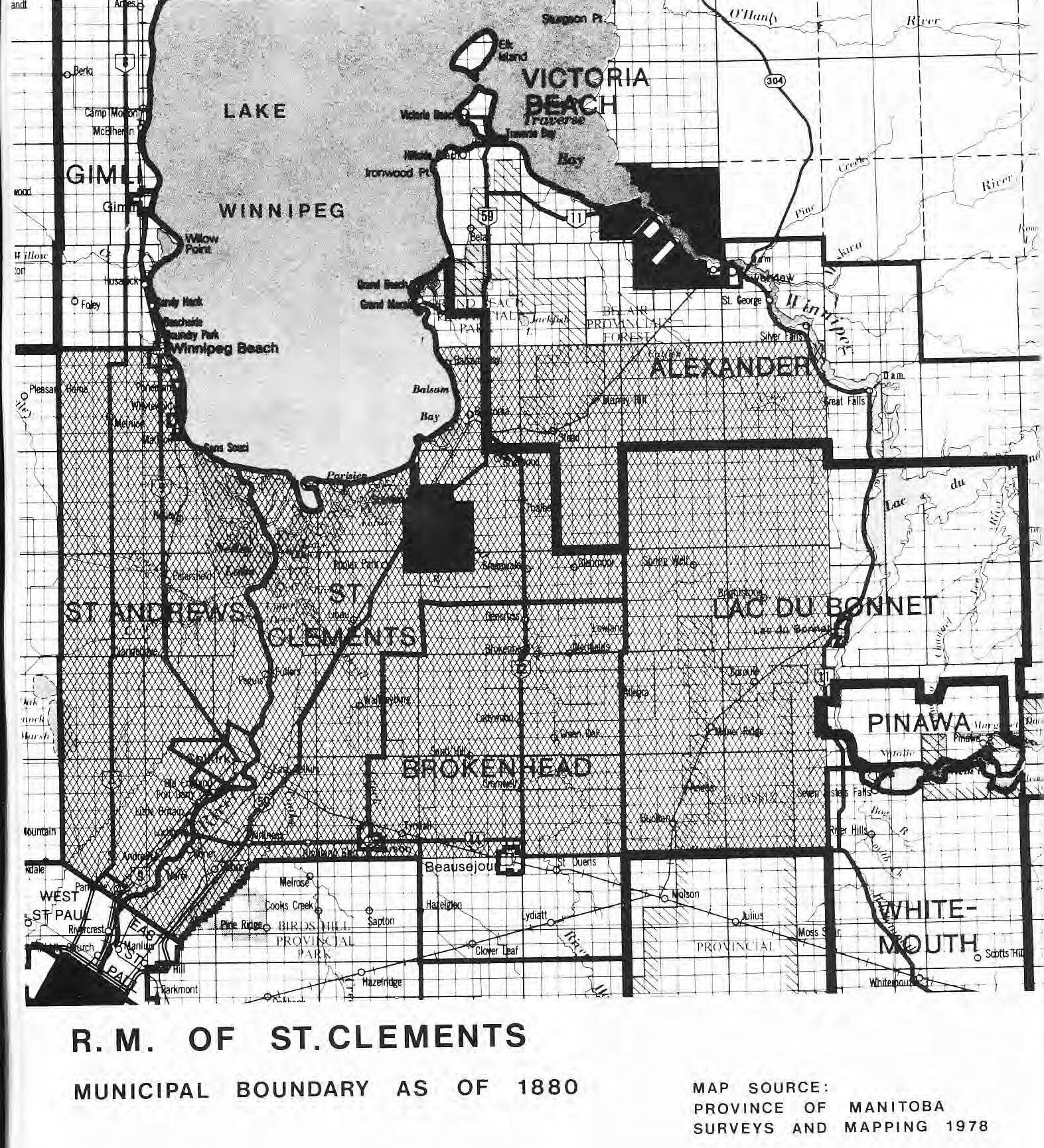
The Municipality of St. Clements shall comprise all the portions of the County of Lisgar, from the Red River to the line between ranges 8 and 9, east, on the east, in townships 13 to 18, both inclusive, whole or fractional, with those portions of the parishes of St. Peters, St. Andrews, and St. Clements, and the lndian Reserve lying east of the Red River, and townships 19 and 20, ranges 7 and 8, east, fractional, east of Lake Winnipeg, except the Town of East Selkirk.
Assented to July 7, 1883.
Proclaimed November 16, 1883.
Effective December 22, 1883.
S.M.47 Victoria 1884, Cap. 11, Sec. 18(No.2/shows no changes in municipal boundaries.
Assented to April 29, 1884.
Proclaimed by section 491 of the said Act.
Effective May 15, 1884.
S.M. 49 Victoria 1886, Cap. 52, Sec. I2 (No.1/ shows no changes in municipal boundaries.
Assented to May 28, 1886.
Proclaimed October 18, 1886.
Effective November 15, 1886.
S.M.53 Victoria 1890, Cap.55, Sec. l4: The rural municipality of St. Clements shall comprise townships 13 to 18, both inclusive, whole or fractional in ranges 5 to 8 east, both inclusive, with those portions of the Parishes of St. Peters, St. Andrews and St. Clements, and the Indian Reserve lying east of the Red River, and townships 19 and 20, ranges 7 and 8 east, fractional, east of Lake Winnipeg; except the town of East Selkirk as incorporated.
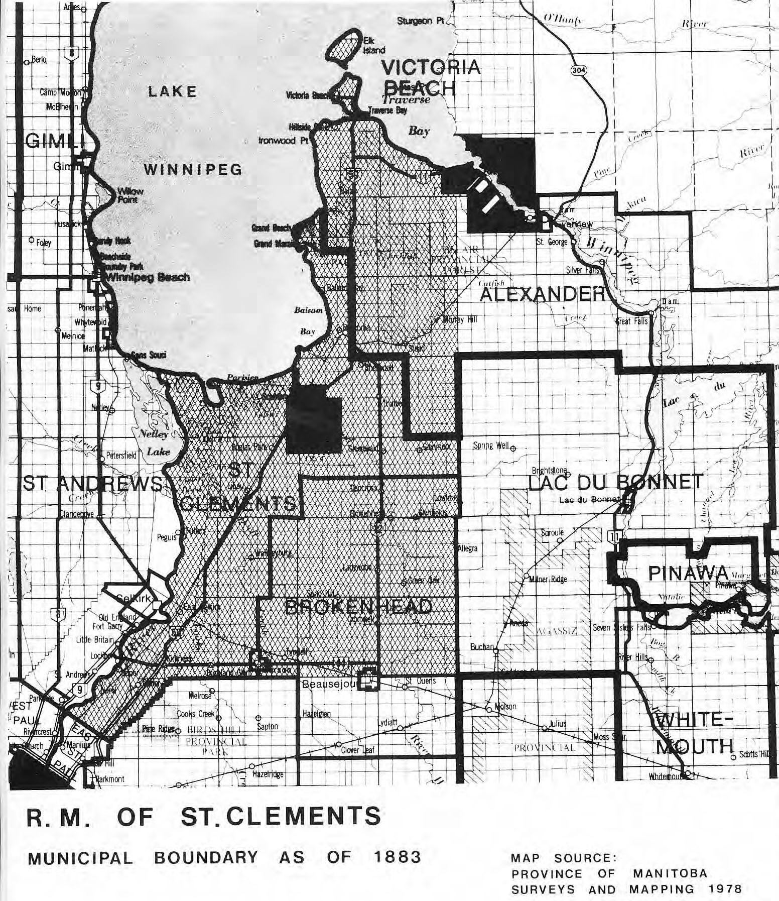
Assented to March 31, 1890.
In force for holding of elections effective November 1, 1890 and for boundaries when new Council is elected and takes office.
R.S.M. 1891, Cap. 102, Sec. 38 shows no changes in municipal boundaries.
S.M. 55 Victoria 1892, Cap. 27, Sec. I amended Sec. 38 of Cap. 102, R.S.M. 1892 by inserting the word “inclusive” in the fourth line thereof, the words “except those portions of range 5 east, included in the Rural Municipality of St. Andrews. “
Assented to and in force April 20, 1892.
S.M. 63 send 64 Victoria 1900, Cap. 36, Sec. 3 amended Sec. 38 of Cap. 102 R.S.M. l89l as amended by Sec. 8 of Cap. 27 S.M. 1892 by adding thereto the following words: “and except townships l3 and 14 and the south half of 15 in ranges 7 and 8 east, and the east half of townships 13 and l4 in range 6 east.”
Assented to July 5, 1900.
Proclaimed November 3, 1900.
Effective November 15. 1900.
S.M. 1902, Cap. 34, Sec.4 amended Sec. 38 of Cap. 102 R.S.M. l89l by adding after the word ‘ ‘incorporated’ ‘ in the ninth line thereof the words “and any portion of Elk Island. “
Assented to and in force March l, 1902. R.S.M. 1902, Cap. 1 18, Sec. 43 shows:
The Rural Municipality of St. Clements shall comprise townships numbered from thirteen to eighteen, both inclusive, whole or fractional, in ranges numbered from five to eight east, both inclusive, (except those portions of range numbered five east included in the Rural Municipality of St. Andrews), with those portions of the parishes of St. Peters, St. Andrews, and St. Clements, and of the lndian Reserve known as “St. Peters Indian Reserve,” lying east of the Red River, and townships numbered nineteen and twenty in ranges numbered seven and eight east, fractional, east of Lake Winnipeg; except the Town of East Selkirk as incorporated and any portion of Elk Island, and except townships numbered thirteen and fourteen and the south half of townships numbered fifteen in ranges numbered seven and eight east and the east halves of townships numbered thirteen and fourteen in range numbered six east.
S.M. 1903 Cap. 29, Sec.4 amends Sec. 43 of said Cap. 118 by striking out all the words in said section after the word “east” in the l5th line thereof, and by substituting there for the following: “half of township 13 in range 6 east, sections 1, 2, l l, 12, 13, 14, 23, 24, 25, 26, 35 and 36 in township 14, in range 6 east. “
S.M. 1904 Cap. 40, Sec..1 amends Sec. 43 of Cap. ll8 R.S.M. 1902 as amended by Sec. 4 of Cap. 29 of 3 Edward VII – S.M. 1903 by striking out the word “except” in the 1lth line of said Sec. 43 and substituting there for “and” immediately at the beginning of the 12th line of said section 43 and substituting there for “except”.
Assented to and in force February 8, 1904.
S.M. 1913 Cap. 42, Sec.5 repeals section 43 of Cap. 118 R.S.M. 1902 as amended by Sec. 4 of Cap. 29 of 3 Edward VII S.M. 1903 and by Sec. I of Cap. 40 of 3 and 4 Edward Vll S.M. and substituted the following:
43. The Rural Municipality of St. Clements shall comprise townships numbered from l3 to 18, both inclusive, whole or fractional, in ranges numbered from 5 to 8 east, both inclusive (except those portions of range 5 east included in the Rural Municipality of St. Andrews), with those portions of the Parishes of St. Peters, St. Andrews and St. Clements, and of the Indian reserve known as “St. Peters Indian reserve,” lying east of the Red River, and the Indian reserve known as “St. Clements lndian reserve,” in townships l5 and 16, in ranges 6 and 7 east, and townships 19 and 20, in ranges 7 and 8 east, fractional, east of Lake Winnipeg, and the Town of Selkirk as incorporated, except any portion of Elk Island, and except townships 13 and 14 and the south half of
township 15, in ranges 7 and 8 east, and the east half of township 13, in range 6 east sections 1,2, ll,12, 13,14, 23, 24, 25, 26, 35 and 36 in township 14, in range 6 east.
R.S.M. 1913 Cap. 136, Sec. 60 shows no change in municipal boundaries.
S.M. 1919 Cap. 71, Sec. 1 amends Sec. 60 of Cap. 136 R.S.M. 1913 by striking out in the seventh and eighth Iines thereof the following words and figures: “townships 19 and 20 in ranges 7 and 8 east” and substituting There for the words and figures “township 19 in ranges 7 and 8 east, and township 20 in range 8 east” and by striking out the 14th line thereof the words “and any portion of Elk Island. “
Assented to and in force March 14, 1919.
S.M. 1921 Cap. 92, Sec. 1 repeals Sec. 60 of Cap. 136 R.S.M. 1913 as amended by Sec. I of Cap. 7l 9 George V.S.M. and substituted there for the following:
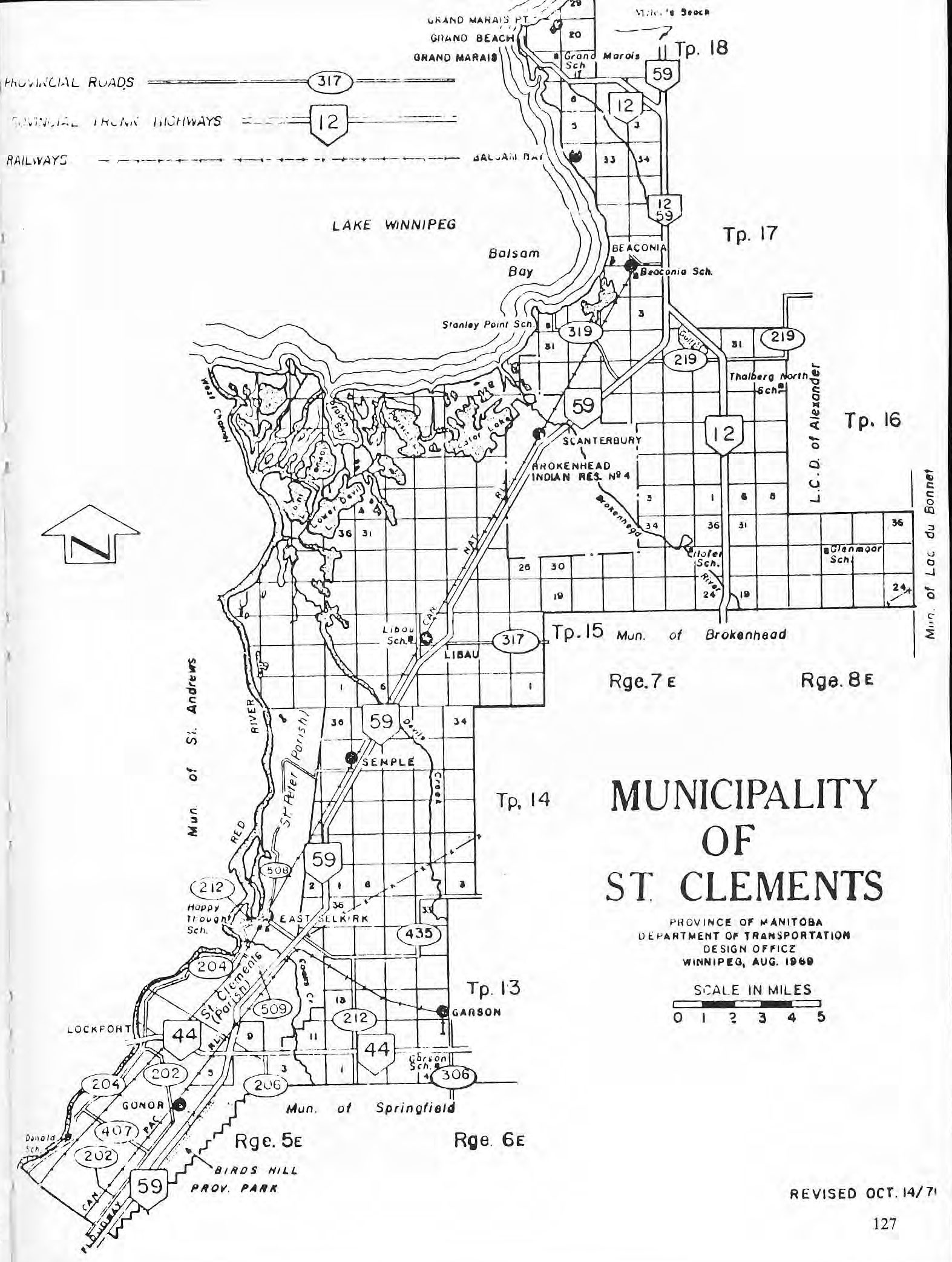
60. The Rural Municipality of St. Clements shall comprise townships thirteen (13), fourteen (14), fifteen (15) and sixteen (16) whole or fractional, lying east of the Red River in range five (5) east; the west half of township thirteen (13), the westerly four tiers of sections in township fourteen (14), all township fifteen (15) and all of fractional township sixteen (16) in range six (6) east; the north half of township fifteen (15) and south half of township sixteen (16), fractional in range seven (7) east; the north half of township fifteen (15) and all of township sixteen (16) in range eight (8) east; those portions of the parishes of St. Peters, St. Andrews and St. Clements and the lndian Reserve known as “St. Peters Indian Reserve” lying east of the Red River, and the lndian Reserve known as “Brokenhead Indian Reserve” in townships fifteen (15) and sixteen (16) in ranges six and seven (6) and (7) east.
Assented to May 7, 1921.
Not Proclaimed – (see R.S.M. 19221).
R.S.M. 1924 Cap. 136, Sec. TT shows The rural municipality of St. Clements shall comprise fractional township 13, in range 5 east, the west half of townships 13 and 14, in range 6 east; township 15, in ranges 5 and 6 east; the north half of township 15, in ranges 7 and 8 east; township 16, in ranges 5 to 8 east; townships 17, 18 and 19, in ranges 7 and 8 east; fractional township 18, in range 6 east: fractional townships l9 and 20, in range 9 east; and those portions of the parishes of St. Peters, St. Andrews and St. Clements, and of the lndian reserve known as “St. Peters Indian reserve,” lying east of the Red River; the lndian reserve known as “St. Clements Indian reserve,” in townships l5 and 16, in ranges 6 and 7 east.
S.M. 1925 Cap. 72, Sec. 1 repeals Sec. 11 of Cap. 136 R.S.M. 1924 and substituted there for:
77. The Rural Municipality of St. Clements shall comprise Township Thirteen, Fourteen, Fifteen and Sixteen, whole or fractional, lying east of the Red River in Range Five east; the west half of Township Thirteen, the westerly four tiers of sections in Township Fourteen all Township Fifteen and all of fractional Township Sixteen in Range Six east; the north half of fractional Township Fifteen and all of Township Sixteen, fractional in Range Seven east; the north half of Township Fifteen and westerly two tiers of sections in Township Sixteen in Range Eight east; all of fractional Township Seventeen in Range Seven east, excepting the most easterly two tiers of sections, all of Township Eighteen Range Seven east, excepting the most easterly two tiers of sections and sections Whole or Fractional Fifteen, Sixteen, Twenty one, Twenty-two, Twenty-seven, Twenty-eight, Thirty three and Thirty-four; those portions of the parishes of St. Peters, St. Andrews and St. Clements and the Indian Reserve known as “St. Peters Indian Reserve” lying east of the Red River. and the lndian Reserve known as “Brokenhead lndian Reserve” in Townships Fifteen and Sixteen, in Ranges Six and Seven east.
Assented to April 9th, 1925.
ln force May 1st, 1925.
S.M. 1936 Cap.6J enacts as follows: Sec. 2 amends Sec. 77 of Cap. 136 R.S.M. 1924 as reenacted by Cap. 12 of S.M. 1925 by adding after the word “east” in the third line thereof the words “of the west channel”.
Sec. 3 defines “west channel” as the Red River and that branch thereof flowing through sections 9, 16, 21, 28 and 29 in township 16 in range 5 east as so designated and shown on a plan of Special Survey of the said lands registered in the Winnipeg Land Titles Office as No. 3764.
Assented to and in force April 7, 1936.
R.S.M. 1940 Cap. 143, Sec. 78 shows no further change in municipal boundaries.
R.S.M. 1951 Cap. 176, Sec. 7 shows no further change in municipal boundaries.
C.C.S.M. Cop. M250, Sec. 6Tshows no further change in municipal boundaries.
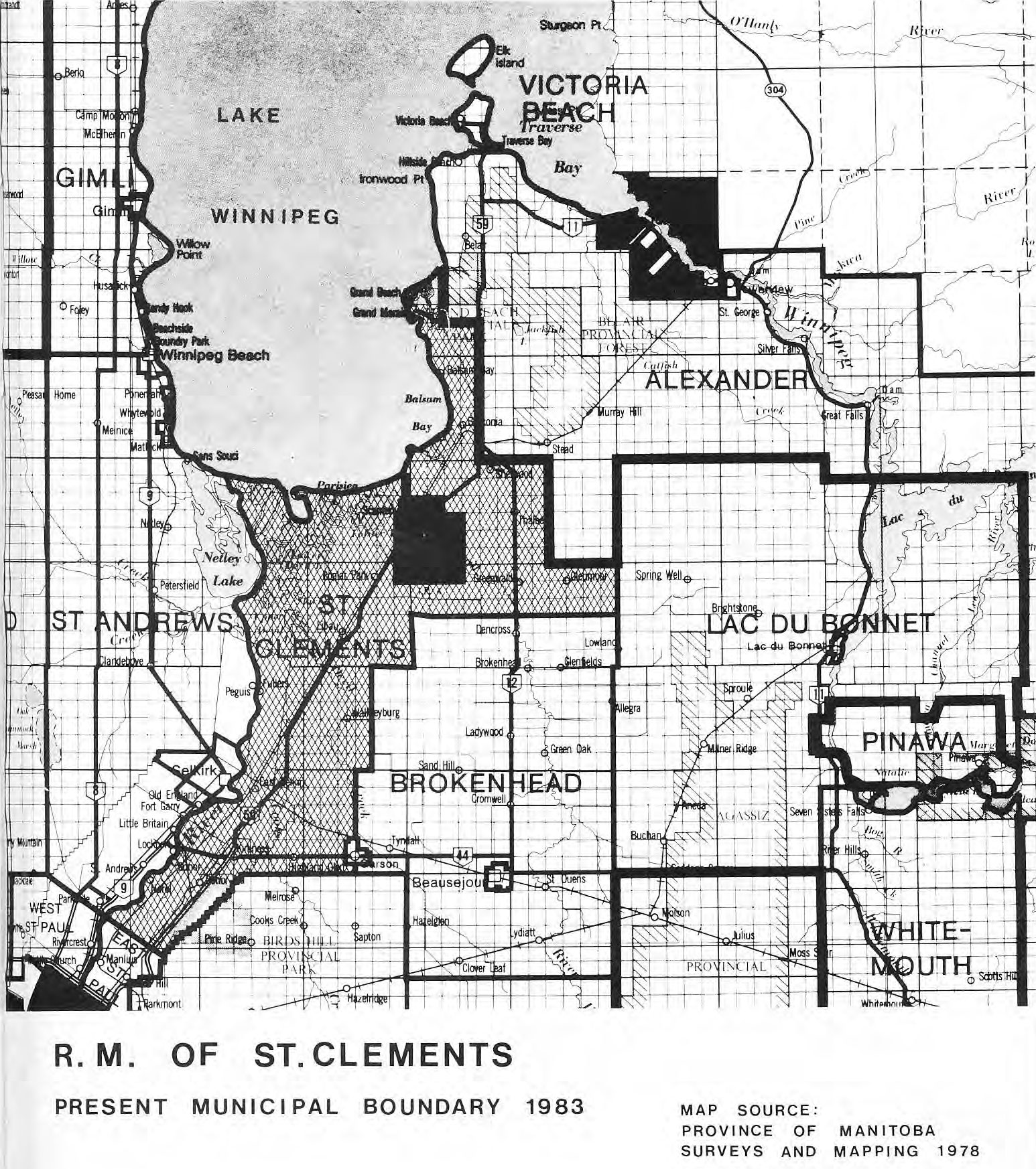
Manitobs Regulation No. 56/80 approved by Order-in- Council No. 255 approved March 12, 1980 withdrew certain lands contained within the Grand Beach Provincial Park, as defined in said Regulation, from the Rural Municipality of St. Clements.
Order-in-Council No. 314 approved April 2, 1980 makes the effective date of Manitoba Regulation No. 56/80 to be January l, 1980.
Manitoba Regulation No. 63/80 approved by Order-in- Council No. 231 which was approved on March 5, 1980 withdrew certain lands contained in the Birds Hill Provincial Park (lands as defined in Order) from the Rural Municipality of Sr. Clement..
Order-in-Council No. 315 approved April 2, 1980 makes the effective date of Manitoba Regulation No. 63/80 to be January l, 1980.