The Lockport Lock and Dam is an architectural marvel. It was constructed to raise water levels on the Red River so that boat traffic could cross over the dangerous Lister Rapids. St. Andrews Lock and Dam was built on a grand vision to expand the shipping industry from Winnipeg to Lake Winnipeg and even into Saskatchewan by making a 5 km stretch of rapids north of Lockport navigable. This vision never came to fruition due to improvements in roads that made overland shipping a better option.
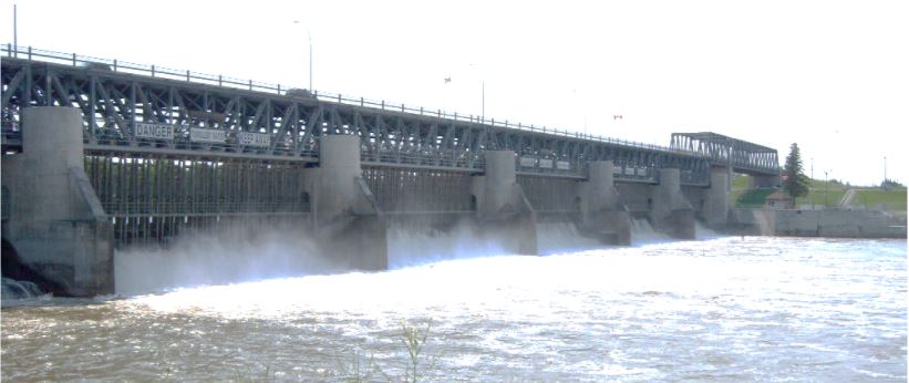
To avoid ice jams, a rare movable-dam style called the Camere design was constructed. The only prototype for this design was located on the Seine River in France. The Camere design is a fixed structure of concrete with a series of steel truss bridges resting on piers. From these piers, a number of frames operate which raise or lower to block the flow of water.
Mr. A.R. Dufresne was the resident supervising engineer, and Mr. A. St. Laurent and Mr. H. Vautelet were the design engineers on the project. The first sod was turned for the Locks on Monday afternoon of October 8, 1900. The workers endured many setbacks including outbreaks of typhoid and the loss of many workers to drowning in the unusually high water. Workers were paid as little as 15 cents an hour for unskilled workers, 25 cents for skilled, and $2.50 per horse team for a 12 hour workday.
When finished, the lock at the west end of the dam could accommodate vessels of about 1600 tons and had a maximum lift of 21 feet. A total of 55,000 cu. yards of concrete and about 6,500,000 pounds of steel were used. In 1899 the estimated cost of the project totaled $150,000 – by 1910 the total cost came in at an astounding 3.5 million dollars.
On July 14, 1910, ten years after the start of the project, Sir Wilfred Laurier officially declared the Locks open. The steamer Winnitoba was the first to pass through the locks with approximately 3000 people on board. Today the locks are used for recreational and passenger vessels. The dam is still used today to provide a stable water level as far upstream as the city of Winnipeg.
Crossing the Red River at Lockport
St. Andrews Lock and Dam geocache site is located in Lockport, Manitoba, Canada at N 50º 04.957´ latitude and W 96º 56.527´ longitude. If you find the geocache and scan the QR code inside of it, it brings you here to learn more. Watch all of our videos on our YouTube Channel. Other heritage content can be found on our Red River North Heritage Youtube channel.
Transcription:
Before the dam was built, there was a series of rapids upstream from Lockport. The major one was the rapids at the St. Andrews Church, which were called the Grand Rapids. This was a major obstacle for shipping products, such as fish, lumber, and minerals, from Lake Winnipeg directly into the docks in Winnipeg. It prevented most vessels larger than a canoe or York Boat from venturing through it except during the spring flood.
Major entrepreneurs, such as William Robinson of the Selkirk Lumber Company, had developed very profitable freight business hauling lumber and fish from the shores of Lake Winnipeg, so direct marketing to Winnipeg would be a big advantage. These business people petitioned the federal government to fix the navigation blockage at Lockport. In 1889, the government of Canada approved an expenditure of $150 000 to improve the St. Andrews rapids problem.
This was greeted with excitement and enthusiasm by many entrepreneurs in the Selkirk and Winnipeg community, however it did have some detractors, such as the land commissioner for the Hudson’s Bay Company, Charles John Bridges. He was of the opinion that navigation on the rivers was a thing of the past, and that the rivers were useless as a means of navigation. Comments like this infuriated many Winnipeg business men because Winnipeg was in a land and building boom, so the supply of local lumber had dried up, due to the use of wood for heating fuel, and local building.
There was huge supply of lumber around Lake Winnipeg that could be shipped directly to the Winnipeg docks at a low cost.
At this time in the late 1880s, there was some major draught in the area, and no steamer had made it up the Red River for the past three years. All freight from Lake Winnipeg, such as fish and lumber, stopped in Selkirk and had to be hauled by road to Winnipeg. The roads were in poor shape, and it was very expensive to haul large loads on these muddy roads.
Rail lines had been recently established to areas such as Selkirk and Gimli, but not further than East Selkirk on the east side of Lake Winnipeg, so most of the Lake Winnipeg area was not accessible, except by water. If the rapids could be navigated at St. Andrews, and a lock system established at Grand Rapids, which was the entry to the Saskatchewan river system, access would be possible to the western edge of Alberta.
This was Sir Wilfred Laurier’s dream when he officially opened the St. Andrews Lock and Dam in 1910. This dam raises the level of the water by 21 feet, and the water level at the Forks by at least nine feet. If it were not for this structure, in a dry year you would likely be able to walk across the Red River at the Forks.
Although the amount of commercial freight traffic along the Red River has been almost eliminated due to better roads and rail options, the tourism potential of the Red River North area has increased with expansion of the catfish and walleye fisheries.
Development of more fuel-efficient motors make it possible for the tourism industries to access the beauties of the Red River North area.