Before roads, the Red River was the main transportation corridor in the area. People settled along the river on both sides. Before bridges were built in early 1900, people crossed the river by ferry or boat.
Almost the entire western boundary of St. Clements borders the Red River. For early settlers, transportation across the river relied heavily on the ferry system. For 15-25 cents local residents could deliver livestock, produce, and grain to the railroad or market. Most destinations for St. Clements residents were the town of Selkirk, local churches, or Lower Fort Garry.
In St. Clements, the most commonly used ferry crossing was between East and West Selkirk. Over the years this ferry changed location numerous times, crossing at Clandeboye Avenue, Manitoba Avenue, and McLean Avenue. The McLean ferry, operated by Mr. Holdgate, was first used in 1917.
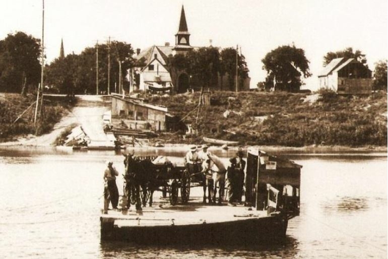
It was constructed using keel joists overlaid with 4 x 8 foot wooden planks placed in parallel sequences. Wooden ramps called aprons were also constructed on the ends of the ferry and were lowered using metal hinges for loading and unloading goods. To pull the ferry across the river, Mr. Holdgate attached a rope to an ox. However, other ferries within the municipality preferred the cable system. In this case, the ferryman would pull the raft across the river along the cable, using a winch-type machine.
Although it was common to transport goods and services by the local ferry, service was often haphazard and dangerous. During the spring and fall when ice flow was treacherous, there were times when the ferry tipped over dumping cars, horses, and people into the river. When the Lockport Dam was completed in 1910 and the Selkirk Bridge in 1937, the ferry system became obsolete.
The River Ferries geocache site is located in near the Red River in Selkirk, Manitoba, Canada at N 50° 08.412 W 096° 52.088. If you find the geocache and scan the QR code inside of it, it brings you here to learn more. Watch all of our videos on our YouTube Channel. Other heritage content can be found on our Red River North Heritage Youtube channel.
Transcription:
Before the building of the Selkirk Bridge, there were two options to get across the river in the summer- by boat, or by ferry. The ferry would take people, wagons, livestock, and a variety of farm produce across the river. Cable ferries were built by communities using a provincial grant from 1870-1881.
During the winter, there was no problem crossing over the ice to the village of Selkirk, but in the fall when the ice started to form, there was no way to cross, as well as in the spring, when the break-up period caused ice jams and high water.
The rowboats that were used were called Red River Punts. They were shaped so that they could move over the ice in the fall or early spring, and were the major method of transport by many residents along the river. Some of them could take eight to nine people.
The ferry was about 24 feet wide, and 40 feet long, and had cables on both sides to keep it going straight. It would also have a cable in the middle that was wound around a drum, powered by a 60-horsepower gas or kerosene engine. This would winch the ferry from one side of the river to the other. In earlier years, oxen were used to pull the ferry across.
When reaching the other side, a ramp was lowered to offload the animals, wagons, and passengers.
The Selkirk ferry was operated by the town and later under a lease agreement. Teams of horses or vehicles were charged 25 cents, and foot passengers five cents one way. If you had to go via the rowboat, the cost was ten cents per person.
A red lantern was always up when the cables were in place to warn passing ships. The cables would be lowered to allow the ship to pass.
In the Selkirk area there were four major ferries located at Little Britain, Mapleton, Selkirk, and St. Peters. The ferry was essential to those living on the east side of the river, to go to the town of Selkirk for supplies, and to go to work, school, or church.
In 1937, the RM of St. Clements had about 10,000 people, including children, about 700 of whom lived in the East Selkirk area at the time. The only bridge across the river north of Winnipeg was the Lockport Bridge, which had been completed in 1914.
It was estimated that, over the years, the Selkirk ferry traffic had involved about 50,000 foot and vehicle passengers.